SOUTHWEST PAPUA | INDONESIA
RAJA AMPAT
UNESCO GLOBAL GEOPARK
THE EMERALD KARST OF THE EQUATOR
A living karst ocean where geology, biodiversity, and indigenous wisdom shape a globally significant model of conservation and sustainable development.
ABOUT
Raja Ampat UNESCO Global Geopark

Raja Ampat is a rare karst archipelago carved over 439–360 million years (Silurian–Devonian) — home to some of the oldest exposed rocks on Earth, revealed in Misool. This region captures nearly one-tenth of Earth’s geological history, preserved like a natural archive of our planet’s evolution.
Positioned at the heart of the Papuan megabiodiversity corridor, Raja Ampat protects globally significant marine and terrestrial ecosystems. Its reefs, forests, and mangroves shelter hundreds of rare, endemic, and endangered species, many found nowhere else on the planet — a core stronghold of the Coral Triangle.
Raja Ampat is also a cultural landscape. Indigenous communities have safeguarded these waters for generations through sasi and other ancestral maritime knowledge systems. From prehistoric cave art in Misool to oral histories and traditional ceremonies, the region’s heritage reflects a deep and enduring relationship between people and nature.
Raja Ampat is not just a destination — it is a living laboratory, a cultural sanctuary, and one of the most important ocean-karst ecosystems on Earth.
About UNESCO Global Geopark
A living karst ocean on the equator where deep-time geology,
world-leading marine biodiversity, and ancestral Papuan culture converge.
OUR BOUNDARIES
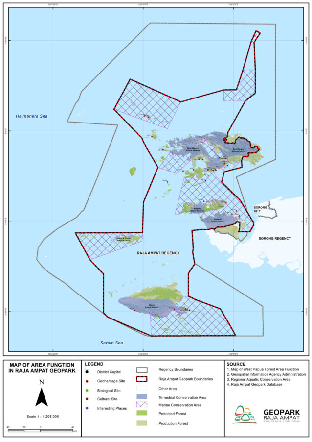
Most of the Geopark area is located in the central part of the Raja Ampat Regency, Southwest Papua Province. However, not all administrative areas are the boundaries of the Raja Ampat Geopark.
2.929
ISLANDS
As a water boundary, the Raja Ampat Geopark uses a Regional Marine Conservation Area and a National Marine Sanctuary.
5
KKPD
2
SAP
On land, the Raja Ampat Geopark is bordered by the district administration area and nature reserves.
8
NATURE RESERVE
OUR MILESTONE
From remote archipelago to internationally recognized living laboratory of Earth and Ocean.
The Geological Survey Center (PSG) revealed that Raja Ampat also has geological significance in its unique rock units, fossils, landforms, and geological processes.
Designated as National Geopark
Promoted to aspiring UNESCO Global Geopark
Evaluation by UNESCO Global Geopark Evaluators, Mr. Charalampos Fassoulas (Greece) and Mr. Alireza Amrikazemi (Iran)
Designated as UNESCO Global Geopark
Designated as UNESCO Biosphere Reserve
1st REVALIDATION
Our progress is rooted in Indigenous knowledge, scientific collaboration, community-based conservation, and transparent governance. This journey continues through structured planning, measurable outcomes, and shared responsibility across government, communities, and knowledge partners.
See how Raja Ampat Geopark is led, managed, and supported by local institutions, experts, and community custodians.
We work with communities, universities, research institutions, and conservation networks to protect and study this living ocean-karst system.
STAY TUNED
TO OUR
SOCIAL MEDIA
LATEST NEWS
We are here if you have a question.
We are happy to open ourselves to share information about the features of Raja Ampat for you. Just write it on!
©2025 Raja Ampat UNESCO Global Geopark Management Body
All Rights Reserved.


